
Washburn County topographic map
Interactive map
Click on the map to display elevation.
About this map
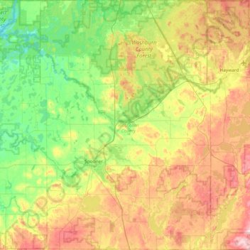
Name: Washburn County topographic map, elevation, terrain.
Location: Washburn County, Wisconsin, USA (45.63776 -92.05103 46.15770 -91.54010)
Average elevation: 358 m
Minimum elevation: 274 m
Maximum elevation: 504 m
Other topographic maps
Click on a map to view its topography, its elevation and its terrain.
Scandinavia
USA > Wisconsin > Scandinavia
Scandinavia, Waupaca County, Wisconsin, USA
Average elevation: 293 m
Sand River
Sand River, Town of Bayfield, Bayfield County, Wisconsin, USA
Average elevation: 258 m
Dodgeville
USA > Wisconsin > Dodgeville
Dodgeville, Iowa County, Wisconsin, USA
Average elevation: 370 m
Gays Mills
USA > Wisconsin > Gays Mills
Gays Mills, Crawford County, Wisconsin, USA
Average elevation: 272 m