
Orange River topographic map
Interactive map
Click on the map to display elevation.
Orange River
During the temperate months of March and April, given good rains and the sluices of the dams being open, a canoeist (or rafter) can easily travel 30 km per day. The lower reaches of the river are most popular, because of the spectacular topography. Commercial tours are available, and these expeditions depart from the border town of Vioolsdrif.
About this map
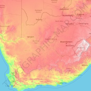
Name: Orange River topographic map, elevation, terrain.
Location: Orange River, South Africa (-30.69413 16.44945 -28.03360 29.07203)
Average elevation: 967 m
Minimum elevation: 0 m
Maximum elevation: 3,373 m
Other topographic maps
Click on a map to view its topography, its elevation and its terrain.
Joubertina
South Africa > Eastern Cape > Sarah Baartman District Municipality > Kou-Kamma Local Municipality
Average elevation: 593 m
Heilbron
South Africa > Free State > Fezile Dabi District Municipality > Ngwathe Local Municipality
Average elevation: 1,559 m
Vegkop
South Africa > KwaZulu-Natal > Umzinyathi District Municipality > Endumeni Local Municipality
Average elevation: 1,231 m
Bela-Bela
South Africa > Limpopo > Waterberg District Municipality > Bela Bela Local Municipality
Average elevation: 1,158 m
Devon
South Africa > Gauteng > Sedibeng District Municipality > Lesedi Local Municipality
Average elevation: 1,656 m
Mabule
South Africa > North West > Ngaka Modiri Molema District Municipality > Ratlou Local Municipality
Average elevation: 1,105 m
Kenton-on-Sea
South Africa > Eastern Cape > Sarah Baartman District Municipality > Ndlambe Local Municipality
Average elevation: 22 m
Langebaan
South Africa > Western Cape > West Coast District Municipality > Saldanha Bay Local Municipality
Average elevation: 34 m
Komani
South Africa > Eastern Cape > Chris Hani District Municipality > Lukhanji Local Municipality
Average elevation: 1,149 m
Riebeek-Wes
South Africa > Western Cape > West Coast District Municipality > Swartland Local Municipality
Average elevation: 262 m
Volksrust
South Africa > Mpumalanga > Gert Sibande District Municipality > Pixley Ka Seme Local Municipality > Volksrust
Average elevation: 1,688 m
Majuba
South Africa > KwaZulu-Natal > Amajuba District Municipality > Newcastle Local Municipality
Average elevation: 1,800 m
Vryheid
South Africa > KwaZulu-Natal > Zululand District Municipality > Abaqulusi Local Municipality > Vryheid
Average elevation: 1,191 m
Lusikisiki
South Africa > Eastern Cape > O.R. Tambo District Municipality > Ingquza Hill Local Municipality
Average elevation: 563 m
Pongola
South Africa > KwaZulu-Natal > Zululand District Municipality > uPhongolo Local Municipality > Pongola
Average elevation: 291 m