
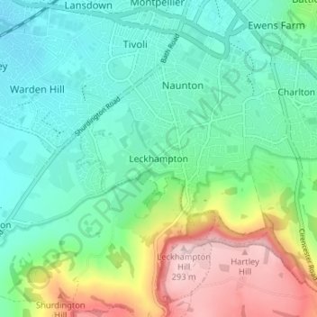
Leckhampton topographic map
Interactive map
Click on the map to display elevation.
About this map
Name: Leckhampton topographic map, elevation, terrain.
Average elevation: 118 m
Minimum elevation: 46 m
Maximum elevation: 293 m
Other topographic maps
Click on a map to view its topography, its elevation and its terrain.
Charlton Kings
United Kingdom > England > Gloucestershire > Cheltenham
Charlton Kings, Cheltenham, Gloucestershire, England, GL53 8BB, United Kingdom
Average elevation: 125 m
Beeches
United Kingdom > England > Gloucestershire > Cheltenham > Charlton Kings
Beeches, Charlton Kings, Cheltenham, Gloucestershire, England, United Kingdom, Timbercombe
Average elevation: 159 m
Leckhampton Hill
United Kingdom > England > Gloucestershire > Cheltenham
Leckhampton Hill, Cirencester Road, Charlton Kings, Cheltenham, Gloucestershire, England, GL53 8EU, United Kingdom
Average elevation: 210 m
Charlton Kings
United Kingdom > England > Gloucestershire > Cheltenham > Charlton Kings
Charlton Kings, Cheltenham, Gloucestershire, England, United Kingdom
Average elevation: 158 m
Prestbury
United Kingdom > England > Gloucestershire > Cheltenham
Prestbury, Cheltenham, Gloucestershire, England, United Kingdom
Average elevation: 63 m
Sudeley Castle
United Kingdom > England > Gloucestershire > Cheltenham > Sudeley
Sudeley Castle, Rushley Lane, Sudeley, Cheltenham, Gloucestershire, England, GL54 5JD, United Kingdom
Average elevation: 135 m
Swindon Village
United Kingdom > England > Gloucestershire > Cheltenham
Swindon Village, Cheltenham, Gloucestershire, England, GL51 9RF, United Kingdom
Average elevation: 43 m