
Thank you for supporting this site ❤️
Make a donation
Make a donation
Klang Municipal Council topographic map
Click on the map to display elevation.
Thank you for supporting this site ❤️
Make a donation
Make a donation
About this map
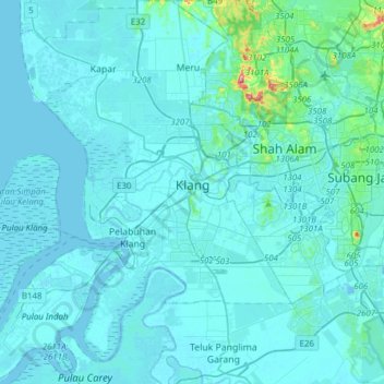
Name: Klang Municipal Council topographic map, elevation, terrain.
Location: Klang Municipal Council, Selangor, Malaysia (2.88484 101.21683 3.19202 101.52408)
Average elevation: 12 m
Minimum elevation: -28 m
Maximum elevation: 213 m
Thank you for supporting this site ❤️
Make a donation
Make a donation
Other topographic maps
Click on a map to view its topography, its elevation and its terrain.