
Summerdale topographic map
Interactive map
Click on the map to display elevation.
About this map
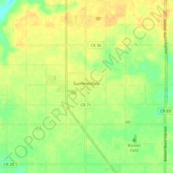
Name: Summerdale topographic map, elevation, terrain.
Location: Summerdale, Baldwin County, Alabama, United States (30.45478 -87.71632 30.51826 -87.67947)
Average elevation: 34 m
Minimum elevation: 18 m
Maximum elevation: 44 m
The Navy Outlying Landing Field (NOLF) Summerdale airport is on the east side of Summerdale (at latitude, longitude: 30.507695, –87.645541). The Airport Code is NFD, in region: ASO - Southern, with boundary ARTCC: ZJX - Jacksonville, and Tie-in FSS: ANB - Anniston. The airport runway length/width is 2850 x 150 ft (868.7 x 45.7 m), with runway elevation: 149 feet (45 m). The airport is owned/operated by the US Navy, through Commanding Officer, Operations Department, 7077 USS Lexington Court, Milton, FL 32570-6016.