
Khangchendzonga National Park topographic map
Interactive map
Click on the map to display elevation.
About this map
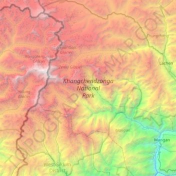
Name: Khangchendzonga National Park topographic map, elevation, terrain.
Average elevation: 4,330 m
Minimum elevation: 599 m
Maximum elevation: 8,521 m
The Kanchenjunga Park is situated in the North and West Sikkim districts in the Indian state of Sikkim. It has an elevation of 1,829 metres (6,001 ft) to over 8,550 metres (28,050 ft) and has an area of 849.50 km2 (327.99 sq mi). It is one of the few high-altitude National parks of India and was recently included as a mixed-criteria UNESCO World Heritage site.
Other topographic maps
Click on a map to view its topography, its elevation and its terrain.
East Sikkim District
India > Sikkim > Pakyong subdivision
East Sikkim District, Pakyong subdivision, Pakyong district, Sikkim, India
Average elevation: 2,107 m
West District
West District, West Sikkim District, Sikkim, 737111, India
Average elevation: 2,636 m
Lachung
India > Sikkim > Chungthang
Lachung, Chungthang, Mangan District, Sikkim, India
Average elevation: 3,617 m
East District
India > Sikkim > East District
East District, East Sikkim District, Sikkim, India
Average elevation: 2,740 m
Zemu Glacier
Zemu Glacier, North District, North Sikkim District, Sikkim, India
Average elevation: 5,499 m
South District
South District, South Sikkim District, Sikkim, India
Average elevation: 2,676 m
North District
North District, North Sikkim District, Sikkim, India
Average elevation: 3,760 m