
Rillito River topographic map
Interactive map
Click on the map to display elevation.
About this map
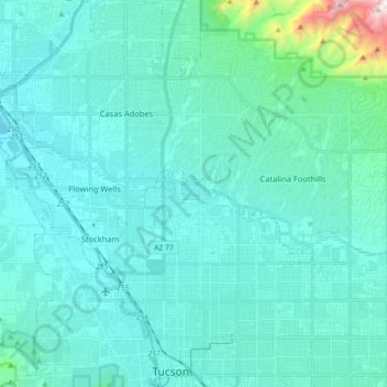
Name: Rillito River topographic map, elevation, terrain.
Location: Rillito River, Tucson, Pima County, Arizona, United States (32.26830 -111.05360 32.31595 -110.87597)
Average elevation: 790 m
Minimum elevation: 643 m
Maximum elevation: 2,064 m
Other topographic maps
Click on a map to view its topography, its elevation and its terrain.
Tucson
United States > Arizona > Pima County > Tucson
The city's elevation is 2,643 ft (806 m) above sea level (as measured at the Tucson International Airport). Tucson is on an alluvial plain in the Sonoran Desert, surrounded by five minor ranges of mountains: the Santa Catalina Mountains and the Tortolita Mountains to the north, the Santa Rita Mountains to the…
Average elevation: 836 m
Drexel Heights
United States > Arizona > Pima County > Tucson
The area has numerous Saguaro cacti, and is positioned only a couple of miles south of the Saguaro National Park. The northern boundary of Drexel Heights is the Tucson Mountain Park. It is cut off from the rest of Tucson due to the topography of the Tucson Mountains, which are only crossed via a small number…
Average elevation: 786 m