
Sissu topographic map
Interactive map
Click on the map to display elevation.
About this map
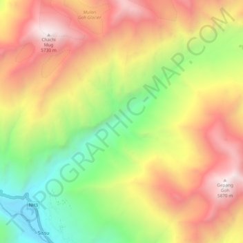
Name: Sissu topographic map, elevation, terrain.
Location: Sissu, Lahul, Lahul and Spiti, Himachal Pradesh, India (32.47773 77.11582 32.53277 77.21007)
Average elevation: 4,343 m
Minimum elevation: 2,996 m
Maximum elevation: 5,793 m
Other topographic maps
Click on a map to view its topography, its elevation and its terrain.