
Grapeview topographic map
Interactive map
Click on the map to display elevation.
About this map
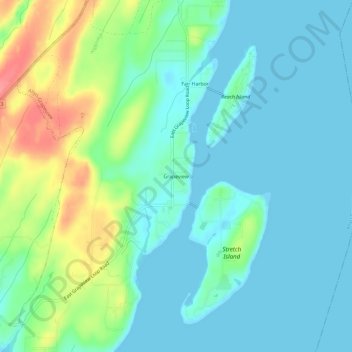
Name: Grapeview topographic map, elevation, terrain.
Location: Grapeview, Mason County, Washington, United States (47.31176 -122.85514 47.35176 -122.81514)
Average elevation: 21 m
Minimum elevation: 0 m
Maximum elevation: 81 m
Other topographic maps
Click on a map to view its topography, its elevation and its terrain.
Mount Skokomish Wilderness
United States > Washington > Mason County
Mount Skokomish Wilderness is located in the southeast corner of Olympic National Forest, just north of Lake Cushman. It consists of two long rocky ridges running roughly northeast to southwest. Elevations range from about 2,000 feet (609.6 m) to 6,434 feet (1,961.1 m) at the peak of Mount Skokomish on the…
Average elevation: 1,058 m