
Creekside Park topographic map
Interactive map
Click on the map to display elevation.
About this map
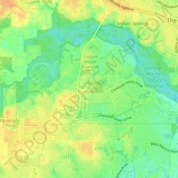
Name: Creekside Park topographic map, elevation, terrain.
Average elevation: 46 m
Minimum elevation: 29 m
Maximum elevation: 61 m
Other topographic maps
Click on a map to view its topography, its elevation and its terrain.
East Shore
United States of America > Texas > The Woodlands > East Shore
East Shore, The Woodlands, Montgomery County, Texas, 77380, United States of America
Average elevation: 45 m