
Santopadre topographic map
Interactive map
Click on the map to display elevation.
About this map
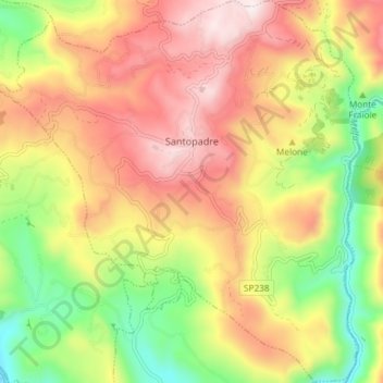
Name: Santopadre topographic map, elevation, terrain.
Location: Santopadre, Frosinone, Lazio, Italia (41.56824 13.59736 41.62334 13.66740)
Average elevation: 478 m
Minimum elevation: 159 m
Maximum elevation: 781 m
Other topographic maps
Click on a map to view its topography, its elevation and its terrain.
Lago di Posta Fibreno
Italia > Lazio > Frosinone > Posta Fibreno
Il lago di Posta Fibreno si trova a un'altitudine di 289 m s.l.m. Le sue dimensioni registrano una lunghezza pari a circa 1 096 m per una larghezza media di 261 m (con una massima di 570 m), con un perimetro di 5 163 m e una superficie complessiva di circa 0,287 km². La profondità media del lago è di 2,5 m,…
Average elevation: 365 m
Monte Cassino
Italia > Lazio > Frosinone > Cassino
Montecassino è un rilievo di 516 metri di altitudine, situato nella parte meridionale della provincia di Frosinone e posto a occidente del centro abitato di Cassino.
Average elevation: 231 m