
Medina Lake topographic map
Interactive map
Click on the map to display elevation.
About this map
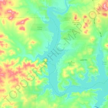
Name: Medina Lake topographic map, elevation, terrain.
Location: Medina Lake, Texas, United States of America (29.53972 -99.00047 29.63999 -98.90060)
Average elevation: 364 m
Minimum elevation: 307 m
Maximum elevation: 476 m
Other topographic maps
Click on a map to view its topography, its elevation and its terrain.
Cochran's Crossing
United States of America > Texas > The Woodlands > Cochran's Crossing
Average elevation: 50 m
Castle Rock Park
United States of America > Texas > College Station > Wellborn
Average elevation: 92 m
Del Mar Heights Colonia
United States of America > Texas > Del Mar Heights Colonia
Average elevation: 6 m