
Alushta topographic map
Interactive map
Click on the map to display elevation.
About this map
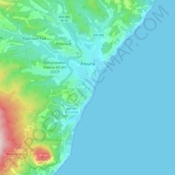
Name: Alushta topographic map, elevation, terrain.
Location: Alushta, Ukraine (44.63221 34.37387 44.70269 34.42582)
Average elevation: 82 m
Minimum elevation: -1 m
Maximum elevation: 537 m
Other topographic maps
Click on a map to view its topography, its elevation and its terrain.
Karpovka
Ukraine > Republic of Crimea > Krasnohvardiiske Raion > Клепининское сельское поселение
Average elevation: 38 m
Volodyne
Ukraine > Autonomous Republic of Crimea > Dzhankoy Raion > Яснополянское сельское поселение
Average elevation: 6 m