
Los Cipreses topographic map
Interactive map
Click on the map to display elevation.
About this map
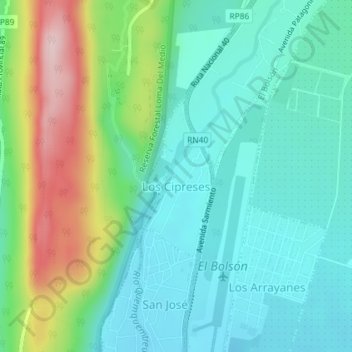
Name: Los Cipreses topographic map, elevation, terrain.
Location: Los Cipreses, El Bolsón, Río Negro, 8430, Argentina (-41.94375 -71.54094 -41.93119 -71.53367)
Average elevation: 400 m
Minimum elevation: 323 m
Maximum elevation: 602 m
Other topographic maps
Click on a map to view its topography, its elevation and its terrain.