
Mount Fuji topographic map
Interactive map
Click on the map to display elevation.
Mount Fuji
There are four major routes to the summit, each has numbered stations along the way. They are (clockwise, starting North): Yoshida, Subashiri, Gotemba, and Fujinomiya routes. Climbers usually start at the fifth stations, as these are reachable by car or by bus. The summit is the tenth station on each trail. The stations on different routes are at different elevations; the highest fifth station is located at Fujinomiya, followed by Yoshida, Subashiri, and Gotemba. There are four additional routes from the foot of the mountain: Shojiko, Yoshida, Suyama, and Murayama routes.
About this map
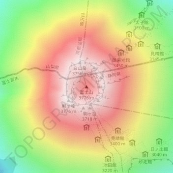
Name: Mount Fuji topographic map, elevation, terrain.
Average elevation: 3,261 m
Minimum elevation: 2,656 m
Maximum elevation: 3,757 m