
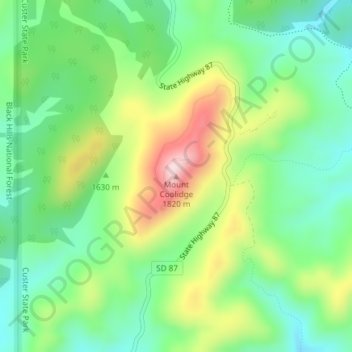
Mount Coolidge topographic map
Interactive map
Click on the map to display elevation.
About this map
Name: Mount Coolidge topographic map, elevation, terrain.
Average elevation: 1,631 m
Minimum elevation: 1,519 m
Maximum elevation: 1,831 m
Other topographic maps
Click on a map to view its topography, its elevation and its terrain.
Brandon
United States of America > South Dakota > Brandon
Brandon, Minnehaha County, South Dakota, 57005, United States of America
Average elevation: 419 m
Mount McKinley
United States of America > South Dakota
Mount McKinley, Harding County, South Dakota, United States of America
Average elevation: 980 m
Ordway
United States of America > South Dakota > Ordway
Ordway, Brown County, South Dakota, United States of America
Average elevation: 399 m
Chinatown
United States of America > South Dakota > Deadwood > Chinatown
Chinatown, Deadwood, Lawrence County, South Dakota, 57732, United States of America
Average elevation: 1,503 m
Clear Lake
United States of America > South Dakota > Clear Lake
Clear Lake, Deuel County, South Dakota, 57226, United States of America
Average elevation: 553 m