
Nagpur topographic map
Interactive map
Click on the map to display elevation.
About this map
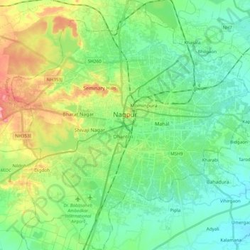
Name: Nagpur topographic map, elevation, terrain.
Location: Nagpur, Maharashtra, India (21.05297 78.99522 21.23100 79.17885)
Average elevation: 309 m
Minimum elevation: 274 m
Maximum elevation: 389 m
Nagpur is located at the exact centre of the Indian subcontinent, close to the geometric centre of the quadrilateral connecting the four major metros of India, viz. Chennai, Mumbai, New Delhi and Kolkata. The city has the Zero Mile Stone locating the geographical centre of India, which was used by the British to measure all distances within the Indian subcontinent. The city lies on the Deccan plateau of the Indian subcontinent and has a mean altitude of 310.5 meters above sea level. The underlying rock strata are covered with alluvial deposits resulting from the flood plain of the Kanhan River. In some places, these give rise to granular sandy soil. In low-lying areas, which are poorly drained, the soil is alluvial clay with poor permeability characteristics. In the eastern part of the city, crystalline metamorphic rocks such as gneiss, schist and granites are found, while in the northern part yellowish sandstones and clays of the lower Gondwana formations are found. Nagpur city is dotted with natural and artificial lakes. The largest lake is Ambazari Lake. Other natural lakes include Gorewada Lake and Telankhedi lake. Sonegaon and Gandhisagar Lakes are artificial, created by the city's historical rulers. Nag river, Pilli Nadi, and nallas form the natural drainage pattern for the city. Nagpur is known for its greenery and was adjudged the cleanest and second greenest in India after Chandigarh in 2010.
Other topographic maps
Click on a map to view its topography, its elevation and its terrain.
Pune
India > Maharashtra > Pune City > Pune
Pune, Pune City, Pune District, Maharashtra, 411001, India
Average elevation: 641 m
Tamnath
India > Maharashtra > Karjat
Tamnath, Karjat, Raigad, Maharashtra, 410201, India
Average elevation: 110 m
Diya
India > Maharashtra > Dharni
Diya, Dharni, Amravati, Maharashtra, 444702, India
Average elevation: 323 m
Panhala Fort
India > Maharashtra > Shahuwadi > Panhala
Panhala Fort, NH166, Panhala, Shahuwadi, Kolhapur, Maharashtra, 416201, India
Average elevation: 825 m
Kaas Valley of Flowers
India > Maharashtra > Jaoli > Daund
Kaas Valley of Flowers, Daund, Jaoli, Satara, Maharashtra, India
Average elevation: 1,011 m
Pimpri-Chinchwad
India > Maharashtra > Haveli
Pimpri-Chinchwad, Haveli, Pune District, Maharashtra, 411089, India
Average elevation: 605 m
Boraj
India > Maharashtra > Chandurbazar
Boraj, Chandurbazar, Amravati, Maharashtra, India
Average elevation: 382 m
Amboli
India > Maharashtra > Sawantwadi
Amboli, Sawantwadi, Sindhudurg, Maharashtra, 416532, India
Average elevation: 734 m
Amboli
India > Maharashtra > Chimur Taluka
Amboli, Chimur Taluka, Chandrapur, Maharashtra, India
Average elevation: 270 m
Gul
India > Maharashtra > Chopda > Ambade
Gul, Ambade, Chopda, Jalgaon, Maharashtra, India
Average elevation: 214 m
Karjat
India > Maharashtra > Karjat
Karjat, Raigad, Maharashtra, 410201, India
Average elevation: 109 m
Chimegaon
India > Maharashtra > Aundha (Nagnath)
Chimegaon, Aundha (Nagnath), Hingoli, Maharashtra, India
Average elevation: 404 m
Chandrapur
India > Maharashtra > Chandrapur
Chandrapur, Maharashtra, 442401, India
Average elevation: 200 m
Pawna Tanda
India > Maharashtra > Himayatnagar
Pawna Tanda, Himayatnagar, Nanded, Maharashtra, India
Average elevation: 465 m
Hasta
India > Maharashtra > Kannad
Hasta, Kannad, Chhatrapati Sambhajinagar, Maharashtra, India
Average elevation: 771 m
Harishchandragad
India > Maharashtra > Akola
Harishchandragad, Akola, Ahmednagar, Maharashtra, India
Average elevation: 992 m
Kalyana
India > Maharashtra > Mehkar > Kalyana
Kalyana, Mehkar, Buldhana, Maharashtra, India
Average elevation: 550 m
Wagholi
India > Maharashtra > Dhamangaon Railway
Wagholi, Dhamangaon Railway, Amravati, Maharashtra, India
Average elevation: 296 m
Pench (Indira Priyadarsini) National Park/Tiger Reserve
India > Maharashtra > Ramtek Taluka
Pench (Indira Priyadarsini) National Park/Tiger Reserve, Ramtek Taluka, Nagpur, Maharashtra, India
Average elevation: 485 m
Chiplun
India > Maharashtra > Chiplun
Chiplun, Ratnagiri, Maharashtra, 415600, India
Average elevation: 69 m
Devagiri Fort
India > Maharashtra > Chhatrapati Sambhajinagar > Daulatabad
Devagiri Fort, Beed Chalisgaon, Daulatabad, Chhatrapati Sambhajinagar, Maharashtra, India
Average elevation: 605 m
Saswad
India > Maharashtra > Purandhar
Saswad, Purandhar, Pune, Maharashtra, 412300, India
Average elevation: 787 m
Omerga
India > Maharashtra > Tuljapur
Omerga, Tuljapur, Dharashiv, Maharashtra, India
Average elevation: 534 m
Vejegaon
India > Maharashtra > Khanapur
Vejegaon, Khanapur, Sangli, Maharashtra, 415310, India
Average elevation: 720 m
Pathari
India > Maharashtra > Lakhani Taluka
Pathari, Lakhani Taluka, Bhandara, Maharashtra, India
Average elevation: 232 m
Lodhi Tola
India > Maharashtra > Tiroda Taluka > Tiroda Town
Lodhi Tola, Tiroda Town, Tiroda Taluka, Gondiya, Maharashtra, 441911, India
Average elevation: 273 m
Nandani
India > Maharashtra > Solapur South
Nandani, Solapur South, Solapur, Maharashtra, India
Average elevation: 445 m
Belghar
India > Maharashtra > Tala
Belghar, Tala, Raigad, Maharashtra, 402111, India
Average elevation: 96 m
Patalganga
India > Maharashtra > Panvel > Apta
Patalganga, Apta, Panvel, Raigad, Maharashtra, India
Average elevation: 85 m
Kharosa
India > Maharashtra > Ausa
Kharosa, Ausa, Latur, Maharashtra, 413521, India
Average elevation: 639 m
Bhukum
India > Maharashtra > Mulshi
Bhukum, Mulshi, Pune, Maharashtra, 412115, India
Average elevation: 706 m
Kolhapur
India > Maharashtra > Deoli
Kolhapur, Deoli, Wardha, Maharashtra, India
Average elevation: 256 m