
Glendive topographic map
Interactive map
Click on the map to display elevation.
About this map
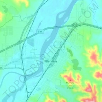
Name: Glendive topographic map, elevation, terrain.
Location: Glendive, Dawson County, Montana, 59330, United States (47.08425 -104.73924 47.13675 -104.67647)
Average elevation: 647 m
Minimum elevation: 620 m
Maximum elevation: 771 m
The elevation of the city is 2,064 feet (629 m). Interstate 94 passes through town with access from exits 215, 224 and 231. Montana Highway 16 begins in West Glendive. The Yellowstone River cuts through town.
Other topographic maps
Click on a map to view its topography, its elevation and its terrain.
West Glendive
United States > Montana > Dawson County
West Glendive, Dawson County, Montana, United States
Average elevation: 652 m
Makoshika State Park
United States > Montana > Dawson County > Glendive
Makoshika State Park, 1301, Glendive, Dawson County, Montana, 59330, United States
Average elevation: 701 m
Makoshika State Park
United States > Montana > Dawson County > Glendive
Makoshika State Park, Glendive, Dawson County, Montana, United States
Average elevation: 698 m