
Baranavichy topographic map
Interactive map
Click on the map to display elevation.
Baranavichy
The city of Baranavichy is located on the Baranavichy Plain in the interfluve of Shchara and its tributary Myshanka. Baranavichy is located virtually on a straight line, connecting the regional center Brest (206 km) and Minsk (149 km). Nearby cities: Lyakhavichy (17 km), Slonim (42 km), Nyasvizh (51 km), Navahrudak (52 km), and Hantsavichy (72 km). Baranavichy is located on flat terrain where the height difference does not exceed 20 m (from 180 to 200 m above sea level). The altitude of the city is 193 m above sea level. The total length of the city is 10 km from west to east and 7 km from south to north. The city is somewhat extended (by 8 km) in the southwest (from Brestskaya Street) to the northeast (to Fabrichnaya Street) and compressed (6.3 km) in the north (Sovetskaya Street) to the southeast (Frolenkov street). The total area occupied by the city is 80.66 km2. (8066 ha as of 12 August 2012). The population density is more than 2,000 people per km2.
About this map
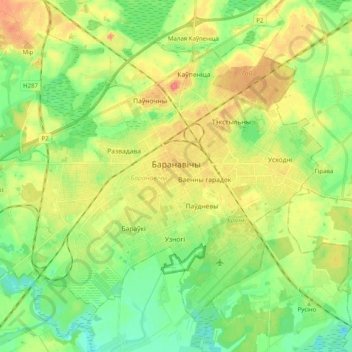
Name: Baranavichy topographic map, elevation, terrain.
Location: Baranavichy, Brest Region, Belarus (53.07980 25.90250 53.17375 26.10154)
Average elevation: 188 m
Minimum elevation: 167 m
Maximum elevation: 215 m
Other topographic maps
Click on a map to view its topography, its elevation and its terrain.