
Make a donation
Snowflake topographic map
Click on the map to display elevation.
Make a donation
About this map
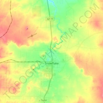
Name: Snowflake topographic map, elevation, terrain.
Location: Snowflake, Navajo County, Arizona, United States (34.48073 -110.16699 34.57153 -110.00841)
Average elevation: 1,736 m
Minimum elevation: 1,671 m
Maximum elevation: 1,810 m
Make a donation
Other topographic maps
Click on a map to view its topography, its elevation and its terrain.
Pinetop-Lakeside
United States > Arizona > Navajo County
Pinetop-Lakeside is nestled in the stunning White Mountains of northeastern Arizona, characterized by a varied topography that significantly influences its natural beauty and recreational opportunities. The terrain features elevations averaging around 6,795 feet, with rugged mountain landscapes interspersed…
Average elevation: 2,087 m
Make a donation
Lake of the Woods
United States > Arizona > Navajo County > Lake of the Woods
Average elevation: 2,037 m
Make a donation
Make a donation
Sierra Plaza subdivision
United States > Arizona > Navajo County > Holbrook
Average elevation: 1,566 m
Make a donation
West Mitten
United States > Arizona > Navajo County
The Mittens are about 0.6 mi (0.97 km) from the Arizona–Utah state line and West Mitten Butte is 1.1 mi (1.8 km) northeast of the park headquarters. The summit of West Mitten Butte is 6,176 ft (1,882 m) and East Mitten Butte is 6,226 ft (1,898 m) in elevation. The Mittens form a triangle with Merrick Butte…
Average elevation: 1,616 m