
Sydney topographic map
Interactive map
Click on the map to display elevation.
About this map
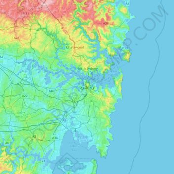
Name: Sydney topographic map, elevation, terrain.
Location: Sydney, New South Wales, 2061, Australia (-34.01482 151.05645 -33.69482 151.37645)
Average elevation: 34 m
Minimum elevation: -17 m
Maximum elevation: 224 m
The Hills district generally refers to the suburbs in north-western Sydney including the local government areas of The Hills Shire, parts of the City of Parramatta Council and Hornsby Shire. Actual suburbs and localities that are considered to be in the Hills District can be somewhat amorphous and variable. For example, the Hills District Historical Society restricts its definition to the Hills Shire local government area, yet its study area extends from Parramatta to the Hawkesbury. The region is so named for its characteristically comparatively hilly topography as the Cumberland Plain lifts up, joining the Hornsby Plateau.
Other topographic maps
Click on a map to view its topography, its elevation and its terrain.
Katoomba
Australia > New South Wales > Sydney
Katoomba, Sydney, Blue Mountains City Council, New South Wales, 2780, Australia
Average elevation: 912 m
Sackville North
Australia > New South Wales > Sydney
Sackville North, Sydney, The Hills Shire Council, New South Wales, 2756, Australia
Average elevation: 37 m
Mount Riverview
Australia > New South Wales > Sydney
Mount Riverview, Sydney, Blue Mountains City Council, New South Wales, 2774, Australia
Average elevation: 201 m
Sydney
Australia > New South Wales > Sydney
Sydney, Council of the City of Sydney, New South Wales, 2000, Australia
Average elevation: 23 m
Wentworth Falls
Australia > New South Wales > Sydney
Wentworth Falls, Sydney, Blue Mountains City Council, New South Wales, 2782, Australia
Average elevation: 708 m
Tregear
Australia > New South Wales > Sydney
Tregear, Sydney, Blacktown City Council, New South Wales, 2770, Australia
Average elevation: 40 m
Schofields
Australia > New South Wales > Sydney
Schofields, Sydney, Blacktown City Council, New South Wales, 2762, Australia
Average elevation: 34 m
Glenbrook
Australia > New South Wales > Sydney
Glenbrook, Sydney, Blue Mountains City Council, New South Wales, 2773, Australia
Average elevation: 168 m
Leura
Australia > New South Wales > Sydney
Leura, Sydney, Blue Mountains City Council, New South Wales, 2780, Australia
Average elevation: 878 m