
Agua Fria National Monument topographic map
Interactive map
Click on the map to display elevation.
Agua Fria National Monument
Situated between 2,150 feet (660 m) and 4,600 feet (1,400 m) in elevation, the monument is primarily composed of semi-desert grassland but also contains extensive riparian stands of cottonwoods and willows which are tied to the Agua Fria River. More than 140 bird species have been recorded at the monument.
About this map
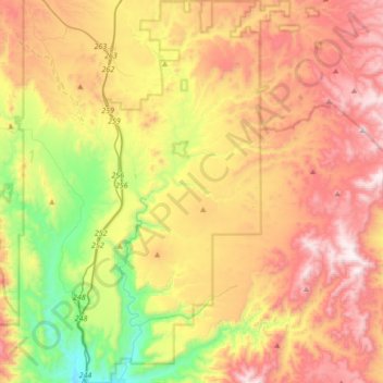
Name: Agua Fria National Monument topographic map, elevation, terrain.
Average elevation: 1,161 m
Minimum elevation: 604 m
Maximum elevation: 1,748 m
Other topographic maps
Click on a map to view its topography, its elevation and its terrain.
Seligman
United States > Arizona > Yavapai County > Seligman
Seligman is located at 35°19′42″N 112°52′27″W / 35.32833°N 112.87417°W / 35.32833; -112.87417 (35.328199, −112.874303), at 5,240 feet (1,600 m) in elevation, alongside the Big Chino Wash, in a northern section of Chino Valley. The wash is a major tributary of the Verde River. Seligman is…
Average elevation: 1,617 m
Lynx Lake
United States > Arizona > Yavapai County
Lynx Lake, Arizona, is a 55-acre (220,000 m2) reservoir located within Prescott National Forest, approximately 5 miles (8.0 km) east of Prescott, Arizona, in the Bradshaw Mountains. The lake is located at 5,530 feet (1,690 m) elevation and is stocked for fishing. It is one of the most popular recreation areas…
Average elevation: 1,726 m
Chino Valley
United States > Arizona > Yavapai County
The town is in north-central Arizona, on state Highway 89, 15 miles (24 km) north of Prescott and 35 miles (56 km) south of Ash Fork, which is on Interstate 40. Chino Valley is at an elevation of about 4,750 feet (1,450 m).
Average elevation: 1,454 m
Black Canyon City
United States > Arizona > Yavapai County
Black Canyon City is located at 34°4′11″N 112°8′22″W / 34.06972°N 112.13944°W / 34.06972; -112.13944 (34.069719, -112.139466), at an elevation of 1,975 feet (602 m).
Average elevation: 700 m
Arcosanti
United States > Arizona > Yavapai County
Arcosanti is a projected experimental town with a bronze bell casting business in Yavapai County, central Arizona, United States, 70 mi (110 km) north of Phoenix, at an elevation of 3,732 feet (1,138 m). Its arcology concept was proposed by Italian-American architect Paolo Soleri (1919–2013). He began…
Average elevation: 1,130 m
Seligman
United States > Arizona > Yavapai County
Seligman is located at 35°19′42″N 112°52′27″W / 35.32833°N 112.87417°W / 35.32833; -112.87417 (35.328199, −112.874303), at 5,240 feet (1,600 m) in elevation, alongside the Big Chino Wash, in a northern section of Chino Valley. The wash is a major tributary of the Verde River. Seligman is…
Average elevation: 1,617 m