
Suhl topographic map
Interactive map
Click on the map to display elevation.
About this map
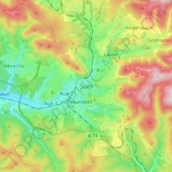
Name: Suhl topographic map, elevation, terrain.
Location: Suhl, Thüringen, 98527, Deutschland (50.56865 10.65264 50.64865 10.73264)
Average elevation: 565 m
Minimum elevation: 382 m
Maximum elevation: 841 m
Suhl liegt in einem in Südrichtung langgezogenen Tal (minimal 380 m über NN) am Süd- bis Westrand des Thüringer Waldes. Die Stadt ist von Bergen zwischen 650 und 983 m Höhe umgeben.
Other topographic maps
Click on a map to view its topography, its elevation and its terrain.
Schneekopf
Deutschland > Thüringen > Suhl
Schneekopf, Suhl, Thüringen, 98528, Deutschland
Average elevation: 855 m
Wichtshausen
Deutschland > Thüringen > Suhl
Wichtshausen, Suhl, Thüringen, 98530, Deutschland
Average elevation: 446 m
Albrechts
Deutschland > Thüringen > Suhl
Albrechts, Suhl, Thüringen, 98529, Deutschland
Average elevation: 491 m
Haardt
Deutschland > Thüringen > Suhl
Haardt, Suhl, Thüringen, 98529, Deutschland
Average elevation: 497 m
Großer Beerberg
Deutschland > Thüringen > Suhl
Großer Beerberg, Suhl, Thüringen, 98528, Deutschland
Average elevation: 853 m
Domberg
Deutschland > Thüringen > Suhl
Domberg, Suhl, Thüringen, 98527, Deutschland
Average elevation: 519 m
Lauter
Deutschland > Thüringen > Suhl > Lauter
Lauter, Suhl, Thüringen, 98527, Deutschland
Average elevation: 569 m
Schmücke
Deutschland > Thüringen > Suhl
Schmücke, Gehlberg, Suhl, Thüringen, 98528, Deutschland
Average elevation: 817 m
Gehlberg
Deutschland > Thüringen > Suhl
Gehlberg, Suhl, Thüringen, Deutschland
Average elevation: 771 m
Heinrichs
Deutschland > Thüringen > Suhl
Heinrichs, Suhl, Thüringen, 98529, Deutschland
Average elevation: 486 m
Heidersbach
Deutschland > Thüringen > Suhl > Heidersbach
Heidersbach, Suhl, Thüringen, 98528, Deutschland
Average elevation: 645 m