
Huachi Grande topographic map
Interactive map
Click on the map to display elevation.
About this map
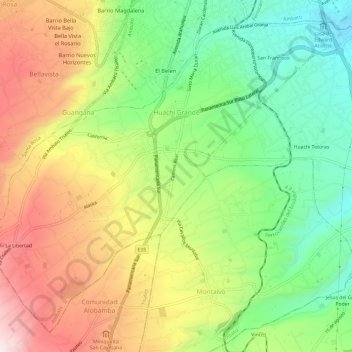
Name: Huachi Grande topographic map, elevation, terrain.
Location: Huachi Grande, Ambato, Tungurahua, Ecuador (-1.33728 -78.66541 -1.28452 -78.60576)
Average elevation: 2,882 m
Minimum elevation: 2,640 m
Maximum elevation: 3,184 m
Other topographic maps
Click on a map to view its topography, its elevation and its terrain.
Calhuasig Chico
Ecuador > Tungurahua > Ambato > Quisapincha > Illagua Chico
Average elevation: 3,336 m
Calhuasig Grande
Ecuador > Tungurahua > Ambato > Quisapincha > Illagua Chico
Average elevation: 3,297 m