
Make a donation
Cape York topographic map
Click on the map to display elevation.
Make a donation
About this map
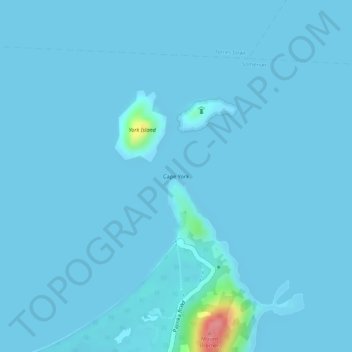
Name: Cape York topographic map, elevation, terrain.
Location: Cape York, Somerset, Torres Shire, Queensland, Australia (-10.68720 142.53151 -10.68710 142.53161)
Average elevation: 3 m
Minimum elevation: 0 m
Maximum elevation: 100 m
Make a donation
Other topographic maps
Click on a map to view its topography, its elevation and its terrain.
City of Brisbane
Brisbane's topography is characterized by a series of hills and ranges that define its landscape. The city is situated on a low-lying floodplain, with the Brisbane River meandering through its heart, creating a winding course with many steep curves from the southwest to its mouth at Moreton Bay in the east.…
Average elevation: 71 m
Sunshine Coast Regional
The Sunshine Coast Regional area in Queensland, Australia, features a diverse topography that ranges from coastal plains to rugged hinterlands. Along the coastline, the terrain is predominantly flat, with average elevations around 20 meters (66 feet) above sea level. Inland, the landscape transitions to…
Average elevation: 56 m
Make a donation
Lama Lama National Park (Cape York Peninsula Aboriginal Land)
Average elevation: 86 m
Make a donation
Brisbane River
The RAAF also perform a practice session in the days preceding the event, serving as an opportunity to both practice beforehand and also promote Riverfire. One of the most popular RAAF aircraft to perform at Riverfire was the F-111 which was known for performing a 'dump-and-burn' above the city. The final…
Average elevation: 235 m
Make a donation
Make a donation
Make a donation
Make a donation
Make a donation
Make a donation
Make a donation
Make a donation
Make a donation
Make a donation
Make a donation
Make a donation
Make a donation
Make a donation
Make a donation
Make a donation
Make a donation
Make a donation
City of Brisbane
Brisbane's topography is characterized by a series of hills and ranges that define its landscape. The city is situated on a low-lying floodplain, with the Brisbane River meandering through its heart, creating a winding course with many steep curves from the southwest to its mouth at Moreton Bay in the east.…
Average elevation: 71 m
Make a donation
Make a donation
Make a donation
Make a donation
Calvert
Australia > Queensland > Ipswich City
The Main Line railway passes through Calvert as does Western Creek, a tributary of the Bremer River. A 2014 flood mapping study of the Western Creek catchment has provided more reliable flood information to residents and landowners. In the northern extents elevations rise to 340 metres above sea level around…
Average elevation: 96 m
Make a donation