
Gokyo Ri topographic map
Interactive map
Click on the map to display elevation.
About this map
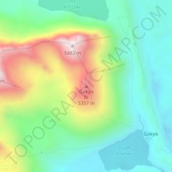
Name: Gokyo Ri topographic map, elevation, terrain.
Average elevation: 4,968 m
Minimum elevation: 4,722 m
Maximum elevation: 5,461 m
Other topographic maps
Click on a map to view its topography, its elevation and its terrain.
Khumbu Glacier
Nepal > Solukhumbu > Khumjung
The Khumbu Glacier (Nepali: खुम्बु हिमनदी) is located in the Khumbu region of northeastern Nepal between Mount Everest and the Lhotse-Nuptse ridge. With elevations of 4,900 m (16,100 ft) at its terminus to 7,600 m (24,900 ft) at its source, it is the world's highest glacier. The Khumbu…
Average elevation: 6,296 m