
Priboj Municipality topographic map
Interactive map
Click on the map to display elevation.
About this map
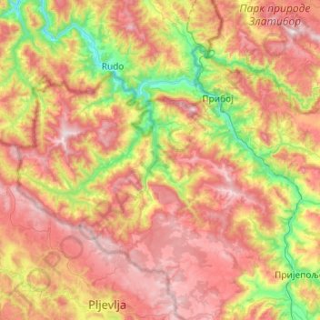
Name: Priboj Municipality topographic map, elevation, terrain.
Average elevation: 888 m
Minimum elevation: 334 m
Maximum elevation: 1,485 m
Other topographic maps
Click on a map to view its topography, its elevation and its terrain.
Бања
Serbia > Central Serbia > Zlatibor Administrative District > Priboj Municipality > Бања
Бања, Priboj Municipality, Zlatibor Administrative District, Central Serbia, 31330, Serbia
Average elevation: 572 m