
Cape Town topographic map
Interactive map
Click on the map to display elevation.
About this map
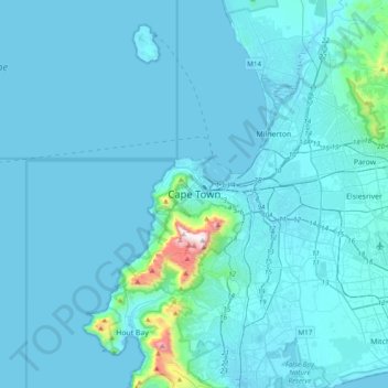
Name: Cape Town topographic map, elevation, terrain.
Average elevation: 53 m
Minimum elevation: -1 m
Maximum elevation: 1,077 m
The Cape Peninsula is 52 km long from Mouille point in the north to Cape Point in the south,[36] with an area of about 470 km2, and it displays more topographical variety than other similar sized areas in southern Africa, and consequently spectacular scenery. There are diverse low-nutrient soils, large rocky outcrops, scree slopes, a mainly rocky coastline with embayed beaches, and considerable local variation in climatic conditions.[37]
Other topographic maps
Click on a map to view its topography, its elevation and its terrain.
Logie Rocks
South Africa > Western Cape > City of Cape Town > Cape Town
Logie Rocks, Cape Town Ward 74, Cape Town, City of Cape Town, Western Cape, 7872, South Africa
Average elevation: 84 m