
Warsaw topographic map
Interactive map
Click on the map to display elevation.
About this map
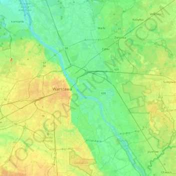
Name: Warsaw topographic map, elevation, terrain.
Location: Warsaw, Masovian Voivodeship, Poland (52.09785 20.85169 52.36815 21.27115)
Average elevation: 95 m
Minimum elevation: 71 m
Maximum elevation: 146 m
Other topographic maps
Click on a map to view its topography, its elevation and its terrain.
Praga-Południe
Poland > Masovian Voivodeship > Warsaw
Praga-Południe, Warsaw, Warszawa, Masovian Voivodeship, Poland
Average elevation: 86 m