
Himachal Pradesh topographic map
Interactive map
Click on the map to display elevation.
About this map
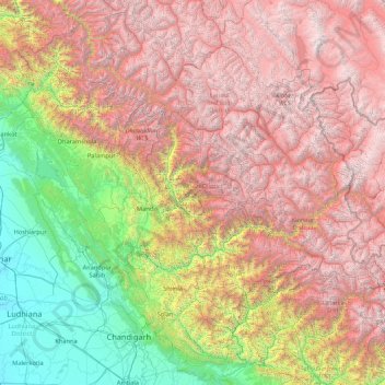
Name: Himachal Pradesh topographic map, elevation, terrain.
Location: Himachal Pradesh, India (30.37717 75.59401 33.25567 79.01238)
Average elevation: 2,869 m
Minimum elevation: 232 m
Maximum elevation: 6,687 m
Due to extreme variation in elevation, great variation occurs in the climatic conditions of Himachal Pradesh. The climate varies from hot and humid subtropical in the southern tracts to, with more elevation, cold, alpine, and glacial in the northern and eastern mountain ranges. The state's winter capital, Dharamsala receives very heavy rainfall, while areas like Lahaul and Spiti are cold and almost rainless. Broadly, Himachal experiences three seasons: summer, winter, and rainy season. Summer lasts from mid-April until the end of June and most parts become very hot (except in the alpine zone which experiences a mild summer) with the average temperature ranging from 28 to 32 °C (82 to 90 °F). Winter lasts from late November until mid-March. Snowfall is common in alpine tracts. Pollution is affecting the climate of almost all the states of India. Due to steps taken by governments to prevent pollution, Himachal Pradesh has become the first smoke-free state in India which means cooking in the entire state is free of traditional chulhas.
Other topographic maps
Click on a map to view its topography, its elevation and its terrain.
Puducherry
India > Puducherry > Puducherry Taluk
Puducherry, Puducherry Taluk, Puducherry District, Puducherry, 605001, India
Average elevation: 10 m
KOLLI HILLS
KOLLI HILLS, Namakkal District, Tamil Nadu, 637411, India
Average elevation: 563 m
Tarapith
India > West Bengal > Rampurhat - II
Tarapith, Rampurhat - II, Birbhum District, West Bengal, 731233, India
Average elevation: 32 m
Bagalkote
India > Karnataka > Bagalakote taluk
Bagalkote, Bagalakote taluk, Bagalkote District, Karnataka, 587102, India
Average elevation: 556 m
Phooliya Kalan Tehsil
Phooliya Kalan Tehsil, Bhilwara District, Rajasthan, India
Average elevation: 374 m
Sliding Rock
India > Andhra Pradesh > Kurabalakota > Mandemvaripalli > Sriramavaripalli
Sliding Rock, Sriramavaripalli, Mandemvaripalli, Kurabalakota, Annamayya District, Andhra Pradesh, 517352, India
Average elevation: 740 m
Moreh
India > Manipur > Tengnoupal tehsil
Moreh, Tengnoupal tehsil, Tengnoupal District, Manipur, 795131, India
Average elevation: 270 m
Kallakurichi
India > Tamil Nadu > Kallakkurichi
Kallakurichi, Kallakkurichi, Kallakurichi District, Tamil Nadu, 606200, India
Average elevation: 124 m
Palanpur
India > Gujarat > Palanpur Taluka
Palanpur, Palanpur Taluka, Banas Kantha District, Gujarat, 385001, India
Average elevation: 218 m
Badami
India > Karnataka > Badami taluku
Badami, Badami taluku, Bagalkote district, Karnataka, 587200, India
Average elevation: 587 m
Brindawan
India > Rajasthan > Beejoliya Tehsil
Brindawan, Beejoliya Tehsil, Bhilwara, Rajasthan, India
Average elevation: 489 m
Malviya Nagar
India > Delhi > Hauz Khas Tehsil
Malviya Nagar, Hauz Khas Tehsil, South Delhi, Delhi, India
Average elevation: 229 m
Gudibande
India > Karnataka > Gudibande taluk
Gudibande, Gudibande taluk, Chikkaballapura district, Karnataka, 561209, India
Average elevation: 833 m
Banganga River
India > Maharashtra > Niphad > Ojhar
Banganga River, Ojhar, Niphad, Nashik, Maharashtra, 422206, India
Average elevation: 584 m
Gudibanda
Gudibanda, Sri Sathya Sai, Andhra Pradesh, 515271, India
Average elevation: 682 m
Bengaluru
India > Karnataka > Bangalore North > Bengaluru
Bengaluru, Bangalore North, Bangalore Urban, Karnataka, 560001, India
Average elevation: 879 m
Bharmour
India > Himachal Pradesh > Brahmaur > Bharmour
Bharmour, Brahmaur, Chamba, Himachal Pradesh, 176315, India
Average elevation: 2,204 m
Laxmidevipally mandal
India > Telangana > Laxmidevipally mandal
Laxmidevipally mandal, Bhadradri Kothagudem, Telangana, 507101, India
Average elevation: 148 m
Ram Nagar
India > Uttar Pradesh > Sambhal > Ram Nagar
Ram Nagar, Sambhal, Uttar Pradesh, India
Average elevation: 204 m
Beerwah
India > Jammu and Kashmir > Beerwah
Beerwah, Budgam District, Jammu and Kashmir, India
Average elevation: 1,785 m
Chini
India > Chhattisgarh > Tamnar Tahsil
Chini, Tamnar Tahsil, Raigarh, Chhattisgarh, India
Average elevation: 337 m
Bandipur National Park/Tiger Reserve
India > Karnataka > Gundlupet taluk
Bandipur National Park/Tiger Reserve, Gundlupet taluk, Chamarajanagar District, Karnataka, India
Average elevation: 860 m
Ganges
India > Uttar Pradesh > Ghazipur
Ganges, Ghazipur, Uttar Pradesh, 233001, India
Average elevation: 1,626 m
Shamirpet mandal
Shamirpet mandal, Medchal–Malkajgiri, Telangana, 500078, India
Average elevation: 574 m
Car Nicobar
India > Andaman and Nicobar Islands
Car Nicobar, Nicobar, Andaman and Nicobar Islands, India
Average elevation: 11 m
Dharavi
India > Maharashtra > Mumbai
Dharavi, Zone 2, Mumbai, Mumbai City, Maharashtra, India
Average elevation: 6 m
Kalimpong
India > West Bengal > Kalimpong
Kalimpong, Kalimpong -I, Kalimpong, West Bengal, 734301, India
Average elevation: 838 m
Secunderabad
India > Telangana > Secunderabad
Secunderabad, Maredpally mandal, Hyderabad, Telangana, 500003, India
Average elevation: 544 m
Jammu
India > Jammu and Kashmir > Jammu
Jammu, Jammu District, Jammu and Kashmir, 180001, India
Average elevation: 367 m