
Amarillo topographic map
Interactive map
Click on the map to display elevation.
About this map
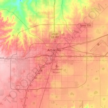
Name: Amarillo topographic map, elevation, terrain.
Location: Amarillo, Potter County, Texas, United States (35.10200 -101.95624 35.29448 -101.65378)
Average elevation: 1,097 m
Minimum elevation: 999 m
Maximum elevation: 1,154 m
Extreme temperatures range from −16 °F (−26.7 °C) on February 12, 1899 to 111 °F (43.9 °C) on June 26, 2011, but lows do not typically dip to 0 °F or −17.8 °C in most years, while highs above 100 °F or 37.8 °C are seen on 4.7 days on average. On average, there are 5.9 days of lows at or below 10 °F or −12.2 °C, 8.8 days where the temperature fails to rise above freezing, and 61 days of 90 °F (32.2 °C)+ highs. Unlike in the Rio Grande Valley or eastern portions of Texas, days where the low does not fall below 70 °F or 21.1 °C are relatively rare, due to the aridity and elevation. Blizzards occur occasionally, but snowfall is typically light, averaging nearly 18 inches or 46 centimetres seasonally and the median figure is near 10 inches or 25 centimetres. Amarillo is also recorded as the windiest city in the U.S. by the Weather Channel.
Other topographic maps
Click on a map to view its topography, its elevation and its terrain.
Amarillo
United States > Texas > Potter County
Amarillo, Potter County, Texas, United States
Average elevation: 1,097 m
Alibates Flint Quarries National Monument
United States > Texas > Potter County
Alibates Flint Quarries National Monument, Potter County, Texas, 79036, United States
Average elevation: 947 m
Bushland
United States > Texas > Potter County
Bushland, Potter County, Texas, 79012, United States
Average elevation: 1,166 m
Amarillo
United States > Texas > Potter County > Amarillo
Amarillo, Potter County, Texas, 79105, United States
Average elevation: 1,090 m