
Aïn Smara topographic map
Interactive map
Click on the map to display elevation.
About this map
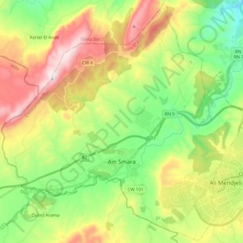
Name: Aïn Smara topographic map, elevation, terrain.
Location: Aïn Smara, Daïra El Khroub, Constantine, Algérie (36.21800 6.40589 36.36337 6.59024)
Average elevation: 765 m
Minimum elevation: 407 m
Maximum elevation: 1,310 m
Other topographic maps
Click on a map to view its topography, its elevation and its terrain.
Ali Mendjeli
Algérie > Constantine > Daïra El Khroub
Ali Mendjeli, El Khroub, Daïra El Khroub, Constantine, 25005, Algérie
Average elevation: 747 m
Charchar
Algérie > Constantine > Daïra El Khroub > El Khroub
Charchar, El Khroub, Daïra El Khroub, Constantine, 25100, Algérie
Average elevation: 612 m
El Khroub
Algérie > Constantine > Daïra El Khroub
El Khroub, Daïra El Khroub, Constantine, Algérie
Average elevation: 769 m
Oued Hammime
Algérie > Constantine > Daïra El Khroub > El Khroub
Oued Hammime, El Khroub, Daïra El Khroub, Constantine, Algérie
Average elevation: 685 m
Ouled Rahmoun
Algérie > Constantine > Daïra El Khroub
Ouled Rahmoun, Daïra El Khroub, Constantine, 25301, Algérie
Average elevation: 813 m
Chelia
Algérie > Constantine > Daïra El Khroub > El Khroub
Chelia, El Khroub, Daïra El Khroub, Constantine, 25040, Algérie
Average elevation: 624 m