
Kyffhäuserland topographic map
Interactive map
Click on the map to display elevation.
About this map
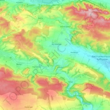
Name: Kyffhäuserland topographic map, elevation, terrain.
Location: Kyffhäuserland, Kyffhäuserkreis, Thüringen, 99707, Deutschland (51.28945 10.90105 51.42959 11.12271)
Average elevation: 267 m
Minimum elevation: 126 m
Maximum elevation: 475 m
Other topographic maps
Click on a map to view its topography, its elevation and its terrain.
Rottleben
Deutschland > Thüringen > Kyffhäuserland
Rottleben, Kyffhäuserland, Kyffhäuserkreis, Thüringen, 99707, Deutschland
Average elevation: 192 m
Kulpenberg
Deutschland > Thüringen > Kyffhäuserland
Kulpenberg, Kyffhäuserland, Kyffhäuserkreis, Thüringen, 06537, Deutschland
Average elevation: 373 m
Badra
Deutschland > Thüringen > Kyffhäuserland
Badra, Kyffhäuserland, Kyffhäuserkreis, Thüringen, Deutschland
Average elevation: 241 m