
Salamanca topographic map
Interactive map
Click on the map to display elevation.
About this map
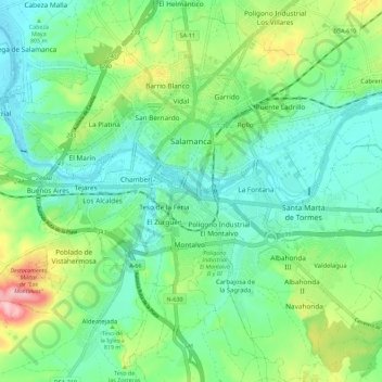
Name: Salamanca topographic map, elevation, terrain.
Location: Salamanca, Castile and León, Spain (40.91463 -5.73580 40.99319 -5.62262)
Average elevation: 812 m
Minimum elevation: 763 m
Maximum elevation: 935 m
The city is located at an altitude of 800 meters above sea level. The altitude of the municipality varies from 911 meters (Los Montalvos), in the southwest, and 763 meters in the last stretch in the municipality of the Tormes river.
Other topographic maps
Click on a map to view its topography, its elevation and its terrain.
Arévalo
Arévalo, Ávila, Castile and León, 05200, Spain
Average elevation: 845 m
La Maya
Spain > Castile and León > La Maya
La Maya, Tierra de Alba, Salamanca, Castile and León, Spain
Average elevation: 850 m
Burgos
Spain > Castile and León > Burgos
Burgos, Alfoz de Burgos, Burgos, Castile and León, Spain
Average elevation: 907 m
Atua
Spain > Castile and León > Condado de Treviño
Atua, Condado de Treviño, Ebro, Burgos, Castile and León, Spain
Average elevation: 629 m
Contreras
Spain > Castile and León > Contreras
Contreras, Sierra de la Demanda, Burgos, Castile and León, Spain
Average elevation: 1,089 m
Pico Almanzor
Spain > Castile and León > Candeleda
Pico Almanzor, Candeleda, Comarca de Arenas de San Pedro, Ávila, Castile and León, Spain
Average elevation: 2,159 m