
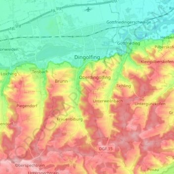
Dingolfing topographic map
Interactive map
Click on the map to display elevation.
About this map
Name: Dingolfing topographic map, elevation, terrain.
Average elevation: 418 m
Minimum elevation: 342 m
Maximum elevation: 504 m
Die Stadt liegt etwa 100 Kilometer nordöstlich von München im Tal der Isar in Niederbayern. Zum Stichtag 1. März 2018 erfolgte eine Höherstufung zu einem Oberzentrum, zuvor handelte es sich um ein Mittelzentrum.
Other topographic maps
Click on a map to view its topography, its elevation and its terrain.
Mietzing
Deutschland > Bayern > Landkreis Dingolfing-Landau > Dingolfing > Schermau
Mietzing, Schermau, Dingolfing, Landkreis Dingolfing-Landau, Bayern, 84180, Deutschland
Average elevation: 458 m
84164
Deutschland > Bayern > Landkreis Dingolfing-Landau > Forst > Burgstall
84164, Burgstall, Forst, Moosthenning, Landkreis Dingolfing-Landau, Bayern, Deutschland
Average elevation: 431 m
Wocka
Deutschland > Bayern > Landkreis Dingolfing-Landau > Niederviehbach
Wocka, Niederviehbach, Landkreis Dingolfing-Landau, Bayern, 84183, Deutschland
Average elevation: 424 m
Wannersdorf
Deutschland > Bayern > Landkreis Dingolfing-Landau
Wannersdorf, Eichendorf, Landkreis Dingolfing-Landau, Bayern, 94428, Deutschland
Average elevation: 371 m
Staudach
Deutschland > Bayern > Landkreis Dingolfing-Landau > Weigendorf
Staudach, Weigendorf, Loiching, Landkreis Dingolfing-Landau, Bayern, 84180, Deutschland
Average elevation: 454 m
Puchhausen
Deutschland > Bayern > Landkreis Dingolfing-Landau
Puchhausen, Mengkofen, Landkreis Dingolfing-Landau, Bayern, 94339, Deutschland
Average elevation: 398 m
Wunder
Deutschland > Bayern > Landkreis Dingolfing-Landau > Hüttenkofen
Wunder, Hüttenkofen, Mengkofen, Landkreis Dingolfing-Landau, Bayern, 84164, Deutschland
Average elevation: 423 m
Frammeringermoos
Deutschland > Bayern > Landkreis Dingolfing-Landau > Landau an der Isar
Frammeringermoos, Landau an der Isar, Landkreis Dingolfing-Landau, Bayern, 94405, Deutschland
Average elevation: 343 m
Hanny
Deutschland > Bayern > Landkreis Dingolfing-Landau > Mengkofen
Hanny, Mengkofen, Landkreis Dingolfing-Landau, Bayern, 94339, Deutschland
Average elevation: 405 m
Wunder
Deutschland > Bayern > Landkreis Dingolfing-Landau > Steinberg
Wunder, Steinberg, Marklkofen, Landkreis Dingolfing-Landau, Bayern, 84163, Deutschland
Average elevation: 444 m
Dornwang
Deutschland > Bayern > Landkreis Dingolfing-Landau
Dornwang, Moosthenning, Landkreis Dingolfing-Landau, Bayern, Deutschland
Average elevation: 389 m
Aiglkofen
Deutschland > Bayern > Landkreis Dingolfing-Landau
Aiglkofen, Marklkofen, Landkreis Dingolfing-Landau, Bayern, 84160, Deutschland
Average elevation: 436 m
Frontenhausen
Deutschland > Bayern > Landkreis Dingolfing-Landau
Frontenhausen, Landkreis Dingolfing-Landau, Bayern, 84160, Deutschland
Average elevation: 457 m
Grünbach
Deutschland > Bayern > Landkreis Dingolfing-Landau > Altersberg
Grünbach, Englmannsberg, Altersberg, Reisbach, Landkreis Dingolfing-Landau, Bayern, 94419, Deutschland
Average elevation: 418 m
Landau an der Isar
Deutschland > Bayern > Landkreis Dingolfing-Landau
Landau an der Isar, Landkreis Dingolfing-Landau, Bayern, 94405, Deutschland
Average elevation: 386 m
Altersberg
Deutschland > Bayern > Landkreis Dingolfing-Landau
Altersberg, Reisbach, Landkreis Dingolfing-Landau, Bayern, 94419, Deutschland
Average elevation: 419 m
Höfen
Deutschland > Bayern > Landkreis Dingolfing-Landau > Simbach
Höfen, Simbach, Landkreis Dingolfing-Landau, Bayern, 94436, Deutschland
Average elevation: 439 m
Teisbach
Deutschland > Bayern > Landkreis Dingolfing-Landau > Dingolfing
Teisbach, Dingolfing, Landkreis Dingolfing-Landau, Bayern, 84180, Deutschland
Average elevation: 398 m
Oberspechtrain
Deutschland > Bayern > Landkreis Dingolfing-Landau
Oberspechtrain, Loiching, Landkreis Dingolfing-Landau, Bayern, 84168, Deutschland
Average elevation: 472 m
Leonsberg
Deutschland > Bayern > Landkreis Dingolfing-Landau > Großköllnbach
Leonsberg, Großköllnbach, Pilsting, Landkreis Dingolfing-Landau, Bayern, 94431, Deutschland
Average elevation: 367 m
Thürnthenning
Deutschland > Bayern > Landkreis Dingolfing-Landau
Thürnthenning, Moosthenning, Landkreis Dingolfing-Landau, Bayern, 84164, Deutschland
Average elevation: 394 m
Holzbuch
Deutschland > Bayern > Landkreis Dingolfing-Landau > Moosthenning
Holzbuch, Moosthenning, Landkreis Dingolfing-Landau, Bayern, 84164, Deutschland
Average elevation: 423 m
Hofdorf
Deutschland > Bayern > Landkreis Dingolfing-Landau
Hofdorf, Mengkofen, Landkreis Dingolfing-Landau, Bayern, 84152, Deutschland
Average elevation: 432 m
Weinpreß
Deutschland > Bayern > Landkreis Dingolfing-Landau > Dingolfing > Teisbach
Weinpreß, Teisbach, Dingolfing, Landkreis Dingolfing-Landau, Bayern, 84130, Deutschland
Average elevation: 399 m
Bachhausen
Deutschland > Bayern > Landkreis Dingolfing-Landau > Mamming
Bachhausen, Mamming, Mamming (VGem), Landkreis Dingolfing-Landau, Bayern, 94437, Deutschland
Average elevation: 391 m
Fellbach
Deutschland > Bayern > Landkreis Dingolfing-Landau > Failnbach > Fellbach
Fellbach, Failnbach, Reisbach, Landkreis Dingolfing-Landau, Bayern, Deutschland
Average elevation: 460 m
Mamming
Deutschland > Bayern > Landkreis Dingolfing-Landau
Mamming, Mamming (VGem), Landkreis Dingolfing-Landau, Bayern, 94437, Deutschland
Average elevation: 400 m
Zirkuswiese
Deutschland > Bayern > Landkreis Dingolfing-Landau > Dingolfing
Zirkuswiese, Geratsberg, Dingolfing, Landkreis Dingolfing-Landau, Bayern, 84130, Deutschland
Average elevation: 377 m
Muggenthal
Deutschland > Bayern > Landkreis Dingolfing-Landau > Indersbach > Muggenthal
Muggenthal, Indersbach, Eichendorf, Landkreis Dingolfing-Landau, Bayern, 94428, Deutschland
Average elevation: 408 m
Höherskirchen
Deutschland > Bayern > Landkreis Dingolfing-Landau > Pischelsdorf > Höherskirchen
Höherskirchen, Pischelsdorf, Simbach, Landkreis Dingolfing-Landau, Bayern, 94436, Deutschland
Average elevation: 450 m
Rothhaus
Deutschland > Bayern > Landkreis Dingolfing-Landau > Rothhaus
Rothhaus, Niederviehbach, Landkreis Dingolfing-Landau, Bayern, 84183, Deutschland
Average elevation: 372 m
Moosthenning
Deutschland > Bayern > Landkreis Dingolfing-Landau
Moosthenning, Landkreis Dingolfing-Landau, Bayern, 84164, Deutschland
Average elevation: 396 m
Göttersberg
Deutschland > Bayern > Landkreis Dingolfing-Landau > Steinberg > Göttersberg
Göttersberg, Steinberg, Marklkofen, Landkreis Dingolfing-Landau, Bayern, 84163, Deutschland
Average elevation: 436 m
Simbach
Deutschland > Bayern > Landkreis Dingolfing-Landau
Simbach, Landkreis Dingolfing-Landau, Bayern, 94436, Deutschland
Average elevation: 428 m
Mengkofen
Deutschland > Bayern > Landkreis Dingolfing-Landau
Mengkofen, Landkreis Dingolfing-Landau, Bayern, 84152, Deutschland
Average elevation: 416 m
Aunkofen
Deutschland > Bayern > Landkreis Dingolfing-Landau > Aunkofen
Aunkofen, Marklkofen, Landkreis Dingolfing-Landau, Bayern, 84163, Deutschland
Average elevation: 426 m
Unterhollerau
Deutschland > Bayern > Landkreis Dingolfing-Landau > Lengthal > Unterhollerau
Unterhollerau, Lengthal, Moosthenning, Landkreis Dingolfing-Landau, Bayern, 84164, Deutschland
Average elevation: 396 m
Landau an der Isar
Deutschland > Bayern > Landkreis Dingolfing-Landau > Landau an der Isar > Landau an der Isar
Landau an der Isar, Landkreis Dingolfing-Landau, Bayern, 94405, Deutschland
Average elevation: 376 m
Eichendorf
Deutschland > Bayern > Landkreis Dingolfing-Landau
Eichendorf, Landkreis Dingolfing-Landau, Bayern, 94428, Deutschland
Average elevation: 382 m
Wallersdorf
Deutschland > Bayern > Landkreis Dingolfing-Landau
Wallersdorf, Landkreis Dingolfing-Landau, Bayern, 94522, Deutschland
Average elevation: 342 m
Niederviehbach
Deutschland > Bayern > Landkreis Dingolfing-Landau
Niederviehbach, Landkreis Dingolfing-Landau, Bayern, 84183, Deutschland
Average elevation: 425 m
Reisbach
Deutschland > Bayern > Landkreis Dingolfing-Landau
Reisbach, Landkreis Dingolfing-Landau, Bayern, 94419, Deutschland
Average elevation: 443 m
Pilsting
Deutschland > Bayern > Landkreis Dingolfing-Landau
Pilsting, Landkreis Dingolfing-Landau, Bayern, 94431, Deutschland
Average elevation: 362 m