
Aschaffenburg topographic map
Interactive map
Click on the map to display elevation.
About this map
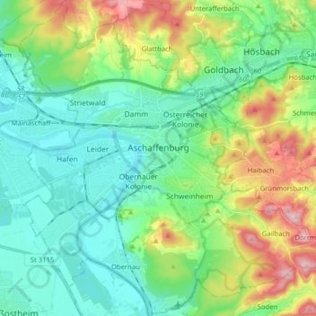
Name: Aschaffenburg topographic map, elevation, terrain.
Location: Aschaffenburg, Bavaria, Germany (49.92006 9.08025 50.02128 9.23800)
Average elevation: 178 m
Minimum elevation: 104 m
Maximum elevation: 366 m
Other topographic maps
Click on a map to view its topography, its elevation and its terrain.
Markt Schwaben
Germany > Bavaria > Landkreis Ebersberg > Markt Schwaben > Markt Schwaben
Average elevation: 513 m
Kleinberg
Germany > Bavaria > Landkreis Neustadt an der Waldnaab > Kirchendemenreuth
Average elevation: 471 m