
Buenos Aires topographic map
Interactive map
Click on the map to display elevation.
About this map
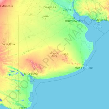
Name: Buenos Aires topographic map, elevation, terrain.
Location: Buenos Aires, Argentina (-41.03834 -63.39274 -33.26161 -56.66506)
Average elevation: 74 m
Minimum elevation: -43 m
Maximum elevation: 1,098 m
Other topographic maps
Click on a map to view its topography, its elevation and its terrain.
Cerro El Plata
Argentina > Mendoza > Distrito La Carrera
Cerro El Plata is the highest peak of the Cordón del Plata which is a subrange of the Andes. The mountain is located 65 kilometres (40 miles) southeast of Aconcagua and 60 kilometres (37 miles) west of the provincial capital, the city of Mendoza. Precipitation runoff from the mountains drains into the Mendoza…
Average elevation: 5,374 m
Andes
Argentina > Mendoza > Distrito Las Cuevas
The Andes Mountains are the highest mountain range outside Asia. The highest mountain outside Asia, Argentina's Mount Aconcagua, rises to an elevation of about 6,961 m (22,838 ft) above sea level. The peak of Chimborazo in the Ecuadorian Andes is farther from the Earth's center than any other location on the…
Average elevation: 6,208 m
Nevado de Cachi
Nevado de Cachi is the name given to a large complex of mountains that lies in Salta Province, Argentina. This complex counts several summits, the highest being 6,380m and it is called Cumbre Libertador. This summit was climbed for the first time in 1950. The mountains overlook Cachi, a traditional village of…
Average elevation: 5,900 m
Piedra del Águila
Argentina > Neuquén Province > Municipio de Piedra del Águila
Average elevation: 539 m
Cerro del Bolsón
While not of great height compared to the 6000 metre-plus peaks of the main chain of the Andes to the west, Bolsón is notable for its high topographic prominence (it ranks 69th in the world), resulting from its separation from the main chain by a relatively low saddle.
Average elevation: 5,057 m
Luján de Cuyo
Argentina > Mendoza > Departamento Luján de Cuyo > Luján de Cuyo
Average elevation: 951 m
Observatorio Parroquial
Argentina > Córdoba > Pedanía Sacanta > Las Varillas > Las Varillas
Average elevation: 136 m
Campo de Mayo
Argentina > Chaco > Municipio de Juan José Castelli > Campo de Mayo
Average elevation: 118 m
General San Martín
Argentina > Buenos Aires > General San Martín > General San Martín
Average elevation: 25 m