
Sidi Rached topographic map
Interactive map
Click on the map to display elevation.
About this map
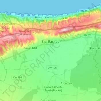
Name: Sidi Rached topographic map, elevation, terrain.
Location: Sidi Rached, Daïra Ahmer El Aïn, Tipaza, 42250, Algérie (36.52557 2.45971 36.57934 2.59701)
Average elevation: 78 m
Minimum elevation: -1 m
Maximum elevation: 266 m
Other topographic maps
Click on a map to view its topography, its elevation and its terrain.
Ahmer El Aïn
Algérie > Tipaza > Daïra Ahmer El Aïn
Ahmer El Aïn, Daïra Ahmer El Aïn, Tipaza, 42005, Algérie
Average elevation: 91 m
Bourkika
Algérie > Tipaza > Daïra Ahmer El Aïn
Bourkika, Daïra Ahmer El Aïn, Tipaza, Algérie
Average elevation: 204 m