
Cascade County topographic map
Interactive map
Click on the map to display elevation.
About this map
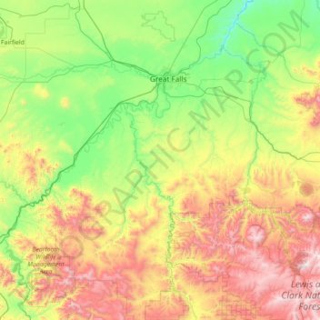
Name: Cascade County topographic map, elevation, terrain.
Location: Cascade County, Montana, United States (46.81790 -112.04796 47.69891 -110.63511)
Average elevation: 1,370 m
Minimum elevation: 831 m
Maximum elevation: 2,601 m
Other topographic maps
Click on a map to view its topography, its elevation and its terrain.
Darby
United States > Montana > Ravalli County
Darby, Ravalli County, Montana, United States
Average elevation: 1,210 m
Helena
United States > Montana > Lewis and Clark County > Helena
Helena, Lewis and Clark County, Montana, United States
Average elevation: 1,296 m
Missoula County
Missoula County, Montana, United States
Average elevation: 1,474 m