
South Delhi topographic map
Interactive map
Click on the map to display elevation.
About this map
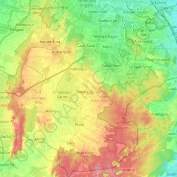
Name: South Delhi topographic map, elevation, terrain.
Location: South Delhi, Delhi, India (28.40463 77.11247 28.56683 77.24707)
Average elevation: 254 m
Minimum elevation: 203 m
Maximum elevation: 316 m
Other topographic maps
Click on a map to view its topography, its elevation and its terrain.
Malviya Nagar
India > Delhi > Hauz Khas Tehsil
Malviya Nagar, Hauz Khas Tehsil, South Delhi, Delhi, India
Average elevation: 229 m
Yamuna River
Yamuna River, Doctor KB Hedgewar Marg, Kashmiri Gate, Majnu Ka Tila, Delhi, Central Delhi, Delhi, 110054, India
Average elevation: 212 m