
Natuna Besar topographic map
Interactive map
Click on the map to display elevation.
About this map
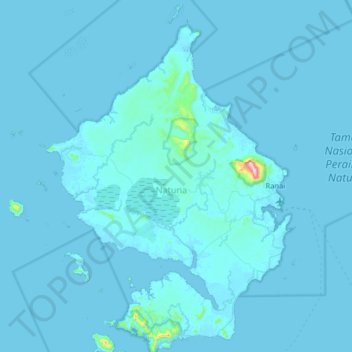
Name: Natuna Besar topographic map, elevation, terrain.
Location: Natuna Besar, Riau Islands, Indonesia (3.63528 107.87876 4.27528 108.51876)
Average elevation: 12 m
Minimum elevation: -3 m
Maximum elevation: 964 m
Other topographic maps
Click on a map to view its topography, its elevation and its terrain.
Terempa Barat
Indonesia > Riau Islands > Terempa Barat
Terempa Barat, Riau Islands, Indonesia
Average elevation: 250 m
Batam City
Indonesia > Riau Islands > Batam City
Batam City, Riau Islands, 29461, Indonesia
Average elevation: 8 m
Bintan Island
Indonesia > Riau Islands > Tanjung Pinang
Bintan Island, Tanjung Pinang, Riau Islands, Indonesia
Average elevation: 6 m