
Canyon Point topographic map
Interactive map
Click on the map to display elevation.
About this map
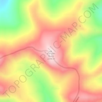
Name: Canyon Point topographic map, elevation, terrain.
Average elevation: 2,081 m
Minimum elevation: 1,796 m
Maximum elevation: 2,288 m
Other topographic maps
Click on a map to view its topography, its elevation and its terrain.
Helena
United States > Montana > Lewis and Clark County
Helena, Lewis and Clark County, Montana, United States
Average elevation: 1,296 m
Craig
United States > Montana > Lewis and Clark County
Craig, Lewis and Clark County, Montana, United States
Average elevation: 1,096 m
Augusta
United States > Montana > Lewis and Clark County > Augusta
Augusta, Lewis and Clark County, Montana, 59410, United States
Average elevation: 1,246 m
Frontier Town
United States > Montana > Lewis and Clark County
Frontier Town, Lewis and Clark County, Montana, United States
Average elevation: 1,870 m
Broadwater
United States > Montana > Lewis and Clark County
Broadwater, Lewis and Clark County, Montana, 59636, United States
Average elevation: 1,284 m
York
United States > Montana > Lewis and Clark County
York, Lewis and Clark County, Montana, United States
Average elevation: 1,348 m
Sugar Loaf
United States > Montana > Lewis and Clark County
Sugar Loaf, Lewis and Clark County, Montana, United States
Average elevation: 1,881 m
Devils Tower
United States > Montana > Lewis and Clark County
Devils Tower, Lewis and Clark County, Montana, United States
Average elevation: 1,373 m
Mount Helena
United States > Montana > Lewis and Clark County > Helena
Mount Helena, Helena, Lewis and Clark County, Montana, 59601, United States
Average elevation: 1,388 m