
Walla Walla topographic map
Interactive map
Click on the map to display elevation.
About this map
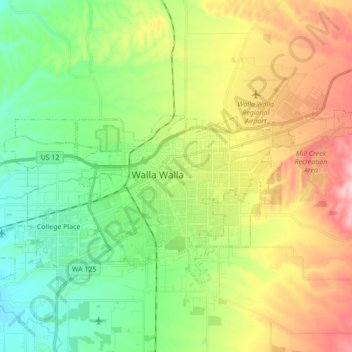
Name: Walla Walla topographic map, elevation, terrain.
Average elevation: 297 m
Minimum elevation: 209 m
Maximum elevation: 417 m
Other topographic maps
Click on a map to view its topography, its elevation and its terrain.
Ice Harbor Dam
United States > Washington > Walla Walla County
Ice Harbor Dam, Walla Walla County, Washington, United States
Average elevation: 149 m
Burbank
United States > Washington > Walla Walla County
Burbank, Walla Walla County, Washington, 99323, United States
Average elevation: 115 m
Waitsburg
United States > Washington > Walla Walla County
Waitsburg, Walla Walla County, Washington, United States
Average elevation: 414 m
Buroker
United States > Washington > Walla Walla County
Buroker, Walla Walla County, Washington, United States
Average elevation: 426 m
Wallula
United States > Washington > Walla Walla County
Wallula, Walla Walla County, Washington, United States
Average elevation: 119 m
Dixie
United States > Washington > Walla Walla County > Dixie
Dixie, Walla Walla County, Washington, 99329, United States
Average elevation: 537 m
Whitman Mission National Historic Site
United States > Washington > Walla Walla County
Whitman Mission National Historic Site, Walla Walla County, Washington, United States
Average elevation: 196 m
College Place
United States > Washington > Walla Walla County
College Place, Walla Walla County, Washington, 99324, United States
Average elevation: 244 m