
At Ta'if topographic map
Interactive map
Click on the map to display elevation.
About this map
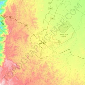
Name: At Ta'if topographic map, elevation, terrain.
Location: At Ta'if, Al Taif, Makkah Region, 26511, Saudi Arabia (21.11028 40.25583 21.43028 40.57583)
Average elevation: 1,742 m
Minimum elevation: 1,010 m
Maximum elevation: 2,595 m
Taif (Arabic: اَلطَّائِفُ, romanized: aṭ-Ṭāʾif, lit. 'The circulated or encircled', Hejazi Arabic pronunciation: [atˤˈ tˤaːjɪf]) is a city and governorate in the Mecca Province of Saudi Arabia. Located at an elevation of 1,879 m (6,165 ft) in the slopes of the Hijaz Mountains, which themselves are part of the Sarat Mountains, the city has a 2020 estimated population of 688,693 people, making it the 6th most populous city in the kingdom.
Other topographic maps
Click on a map to view its topography, its elevation and its terrain.
Makkah Al Mukarramah
Makkah Al Mukarramah, Makkah Region, Saudi Arabia
Average elevation: 479 m