
Pontevedra topographic map
Interactive map
Click on the map to display elevation.
About this map
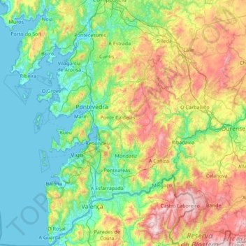
Name: Pontevedra topographic map, elevation, terrain.
Location: Pontevedra, Galicia, Spain (41.86393 -8.94963 42.86016 -7.86143)
Average elevation: 339 m
Minimum elevation: -2 m
Maximum elevation: 1,399 m
Other topographic maps
Click on a map to view its topography, its elevation and its terrain.
Santiago de Compostela
Spain > Galicia > Santiago de Compostela
The cathedral borders the main plaza of the old and well-preserved city. According to medieval legend, the remains of the apostle James were brought to Galicia for burial; in 813, the light of a bright star guided a shepherd who was watching his flock at night to the burial site in Santiago de Compostela. This…
Average elevation: 248 m