
Grocka Urban Municipality topographic map
Interactive map
Click on the map to display elevation.
Grocka Urban Municipality
The municipality is located east of Belgrade, in the northern part of Šumadija region, with the northern section being part of the Podunavlje macro-region in the valley of the Danube, while the southern section is located around the valley of the Ralja River, which is a tributary to the Velika Morava's arm of Jezava. With an altitude of 71 meters above sea level, the town of Grocka is one of the lowest parts of Belgrade. Other rivers in the municipality are Bolečica and Gročica. Being polluted, by 2019 the environmentalists described both rivers as "less of a watercourses, more of a sewage watersheds".
About this map
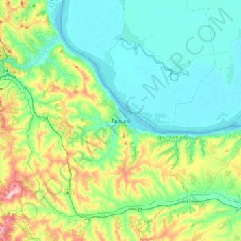
Name: Grocka Urban Municipality topographic map, elevation, terrain.
Average elevation: 146 m
Minimum elevation: 66 m
Maximum elevation: 396 m
Other topographic maps
Click on a map to view its topography, its elevation and its terrain.
Dren
Serbia > Central Serbia > City of Belgrade > Obrenovac Urban Municipality
Average elevation: 98 m
Vlaska
Serbia > Central Serbia > City of Belgrade > Mladenovac Urban Municipality
Average elevation: 225 m
Rabrovac
Serbia > Central Serbia > City of Belgrade > Mladenovac Urban Municipality
Average elevation: 160 m
Barajevo
Serbia > Central Serbia > City of Belgrade > Barajevo Urban Municipality
The municipality is located in the lower northern part of Šumadija, southeast of the Belgrade, with an elevation spanning from 140 meters to 364 meters. Most of the municipal territory belongs to the drainage area of the Turija river, right tributary of the Peštan river, which in turn flows into the…
Average elevation: 175 m
Koracica
Serbia > Central Serbia > City of Belgrade > Mladenovac Urban Municipality
Average elevation: 251 m
Jagnjilo
Serbia > Central Serbia > City of Belgrade > Mladenovac Urban Municipality
Average elevation: 155 m
Stojnik
Serbia > Central Serbia > City of Belgrade > Sopot Urban Municipality
Average elevation: 230 m
Begaljica
Serbia > Central Serbia > City of Belgrade > Grocka Urban Municipality
The village is located at the water source of the Begaljica river. The houses are located in the valley sides and flat areas nearer the river, while a large part is located on the hill as well. The highest elevations are at Gornji Kraj and Brđani. The atar (cadastral area) is large, while half of it is…
Average elevation: 182 m
Velika Ivanca
Serbia > Central Serbia > City of Belgrade > Mladenovac Urban Municipality
Average elevation: 226 m
Avala
Serbia > Central Serbia > City of Belgrade > Beli Potok
It is still debated whether Šuplja Stena is a natural cave or was completely dug for the mining purposes. Remains of the Neanderthal culture were discovered in it. In his 1943 Prehistoric mine Šuplja Stena on Avala hill near Belgrade (Serbia), Vladimir Milojčić said that the "cave is old as Avala", formed…
Average elevation: 297 m
Baric
Serbia > Central Serbia > City of Belgrade > Obrenovac Urban Municipality
Average elevation: 109 m