
Rio Grande topographic map
Interactive map
Click on the map to display elevation.
About this map
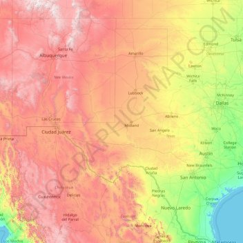
Name: Rio Grande topographic map, elevation, terrain.
Location: Rio Grande, Reeves County, Texas, 88006, USA (25.83706 -107.54317 37.82449 -97.14506)
Average elevation: 1,042 m
Minimum elevation: -1 m
Maximum elevation: 4,035 m
Other topographic maps
Click on a map to view its topography, its elevation and its terrain.