
Antietam topographic map
Interactive map
Click on the map to display elevation.
About this map
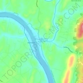
Name: Antietam topographic map, elevation, terrain.
Location: Antietam, Washington County, Maryland, 21782, United States (39.39621 -77.76222 39.43621 -77.72222)
Average elevation: 123 m
Minimum elevation: 85 m
Maximum elevation: 217 m
Other topographic maps
Click on a map to view its topography, its elevation and its terrain.
Hagerstown
United States > Maryland > Washington County
Hagerstown, Washington County, Maryland, United States
Average elevation: 170 m
Keedysville
United States > Maryland > Washington County
Keedysville, Washington County, Maryland, United States
Average elevation: 129 m
Weverton
United States > Maryland > Washington County
Weverton, Washington County, Maryland, 21758, United States
Average elevation: 153 m
Halfway
United States > Maryland > Washington County
Halfway, Washington County, Maryland, United States
Average elevation: 171 m
Williamsport
United States > Maryland > Washington County
Williamsport, Washington County, Maryland, United States
Average elevation: 127 m
Robinwood
United States > Maryland > Washington County > Robinwood
Robinwood, Washington County, Maryland, United States
Average elevation: 175 m
Cavetown
United States > Maryland > Washington County
Cavetown, Washington County, Maryland, 21720, United States
Average elevation: 259 m
Wilson-Conococheague
United States > Maryland > Washington County
Wilson-Conococheague, Washington County, Maryland, United States
Average elevation: 140 m
Paramount-Long Meadow
United States > Maryland > Washington County > Paramount
Paramount-Long Meadow, Paramount, Washington County, Maryland, 21742, United States
Average elevation: 177 m
Cascade
United States > Maryland > Washington County
Cascade, Washington County, Maryland, 21719, United States
Average elevation: 436 m
Antietam National Battlefield
United States > Maryland > Washington County > Sharpsburg
Antietam National Battlefield, Sharpsburg, Washington County, Maryland, 21782, United States
Average elevation: 147 m
Big Pool Lake
United States > Maryland > Washington County > Big Pool
Big Pool Lake, Big Pool, Washington County, Maryland, United States
Average elevation: 143 m
Saint James Village
United States > Maryland > Washington County
Saint James Village, Washington County, Maryland, 21746, United States
Average elevation: 154 m
Sharpsburg
United States > Maryland > Washington County > Sharpsburg
Sharpsburg, Washington County, Maryland, United States
Average elevation: 138 m
Pleasant Valley
United States > Maryland > Washington County
Pleasant Valley, Washington County, Maryland, 21783, United States
Average elevation: 462 m
Smithsburg
United States > Maryland > Washington County
Smithsburg, Washington County, Maryland, 21783, United States
Average elevation: 244 m
Dargan
United States > Maryland > Washington County
Dargan, Washington County, Maryland, 21782, United States
Average elevation: 158 m
Mount Lena
United States > Maryland > Washington County > Mount Lena
Mount Lena, Washington County, Maryland, United States
Average elevation: 243 m
Hancock
United States > Maryland > Washington County > Hancock > Hancock
Hancock, Washington County, Maryland, 21750, United States
Average elevation: 166 m
Hillside
United States > Maryland > Washington County > Hillside
Hillside, Washington County, Maryland, United States
Average elevation: 181 m
Greenbrier State Park
United States > Maryland > Washington County > San Mar
Greenbrier State Park, Mountain Laurel Road, San Mar, Washington County, Maryland, 21713, United States
Average elevation: 305 m
Boonsboro
United States > Maryland > Washington County
Boonsboro, Washington County, Maryland, 21713, United States
Average elevation: 193 m
Clear Spring
United States > Maryland > Washington County
Clear Spring, Washington County, Maryland, United States
Average elevation: 176 m
Hancock
United States > Maryland > Washington County
Hancock, Washington County, Maryland, United States
Average elevation: 167 m
Bakersville
United States > Maryland > Washington County
Bakersville, Washington County, Maryland, 21733, United States
Average elevation: 137 m