
Westminster topographic map
Interactive map
Click on the map to display elevation.
About this map
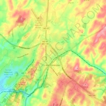
Name: Westminster topographic map, elevation, terrain.
Location: Westminster, Carroll County, Maryland, United States (39.54647 -77.04708 39.62053 -76.95920)
Average elevation: 226 m
Minimum elevation: 159 m
Maximum elevation: 290 m
Westminster lies in the humid subtropical climate zone, with hot and humid summers and cool winters with highly variable seasonal snowfall. Due to its elevation, distance from the Chesapeake Bay and urban heat island, temperatures in Westminster are often considerably lower than in Baltimore, especially at night.
Other topographic maps
Click on a map to view its topography, its elevation and its terrain.
Mount Airy
United States > Maryland > Carroll County
Mount Airy, Carroll County, Maryland, 21771, United States
Average elevation: 221 m
Bear Branch
United States > Maryland > Carroll County > Brown Heights
Bear Branch, Brown Heights, Carroll County, Maryland, United States
Average elevation: 145 m
Belle Grove Square
United States > Maryland > Carroll County > Westminster
Belle Grove Square, Westminster, Carroll County, Maryland, 21157, United States
Average elevation: 224 m
Finksburg
United States > Maryland > Carroll County
Finksburg, Carroll County, Maryland, 21048, United States
Average elevation: 158 m
Hampstead
United States > Maryland > Carroll County
Hampstead, Carroll County, Maryland, United States
Average elevation: 242 m
New Windsor
United States > Maryland > Carroll County
New Windsor, Carroll County, Maryland, United States
Average elevation: 154 m
Eldersburg
United States > Maryland > Carroll County
Eldersburg, Carroll County, Maryland, 21784, United States
Average elevation: 166 m
Keymar
United States > Maryland > Carroll County
Keymar, Carroll County, Maryland, 21757, United States
Average elevation: 128 m
Gaither
United States > Maryland > Carroll County
Gaither, Carroll County, Maryland, 21784, United States
Average elevation: 161 m
Union Bridge
United States > Maryland > Carroll County
Union Bridge, Carroll County, Maryland, United States
Average elevation: 138 m
Avondale Wildlife Management Area
United States > Maryland > Carroll County > Chapel Heights
Avondale Wildlife Management Area, Chapel Heights, Carroll County, Maryland, United States
Average elevation: 206 m
Melrose
United States > Maryland > Carroll County
Melrose, Carroll County, Maryland, United States
Average elevation: 262 m
Heritage
United States > Maryland > Carroll County
Heritage, Carroll County, Maryland, United States
Average elevation: 214 m
Washington Heights
United States > Maryland > Carroll County > Westminster
Washington Heights, Westminster, Carroll County, Maryland, 21157, United States
Average elevation: 233 m
Taneytown
United States > Maryland > Carroll County
Taneytown, Carroll County, Maryland, 21787, United States
Average elevation: 153 m
Millers
United States > Maryland > Carroll County
Millers, Carroll County, Maryland, 21102, United States
Average elevation: 266 m
Union Mills Homestead Park
United States > Maryland > Carroll County > Union Mills
Union Mills Homestead Park, Union Mills, Carroll County, Maryland, United States
Average elevation: 195 m
Furnace Hills
United States > Maryland > Carroll County > Westminster
Furnace Hills, Westminster, Carroll County, Maryland, 21157, United States
Average elevation: 211 m
Marston
United States > Maryland > Carroll County
Marston, Carroll County, Maryland, 21776, United States
Average elevation: 189 m
Liberty Reservoir
United States > Maryland > Carroll County
Liberty Reservoir, Carroll County, Maryland, United States
Average elevation: 170 m
Cape Horn South
United States > Maryland > Carroll County
Cape Horn South, Carroll County, Maryland, United States
Average elevation: 256 m
Meadow Brook
United States > Maryland > Carroll County > Taneytown
Meadow Brook, Taneytown, Carroll County, Maryland, 21787, United States
Average elevation: 156 m
Woodbine
United States > Maryland > Carroll County
Woodbine, Carroll County, Maryland, 21797, United States
Average elevation: 182 m
Mill Stream Hills
United States > Maryland > Carroll County
Mill Stream Hills, Carroll County, Maryland, 21088, United States
Average elevation: 238 m
Silver Run
United States > Maryland > Carroll County
Silver Run, Carroll County, Maryland, United States
Average elevation: 198 m
Eldersburg
United States > Maryland > Carroll County > Eldersburg
Eldersburg, Carroll County, Maryland, 21784, United States
Average elevation: 167 m
Forest Hills
United States > Maryland > Carroll County > Forest Hills
Forest Hills, Carroll County, Maryland, 21157, United States
Average elevation: 227 m
Manchester
United States > Maryland > Carroll County
Manchester, Carroll County, Maryland, United States
Average elevation: 276 m
Mount Airy
United States > Maryland > Carroll County > Mount Airy > Mount Airy
Mount Airy, Carroll County, Maryland, 21771, United States
Average elevation: 217 m
Sykesville
United States > Maryland > Carroll County
Sykesville, Carroll County, Maryland, United States
Average elevation: 152 m
Piney Creek
United States > Maryland > Carroll County
Piney Creek, Carroll County, Maryland, 21787, United States
Average elevation: 152 m