
Barstow topographic map
Interactive map
Click on the map to display elevation.
About this map
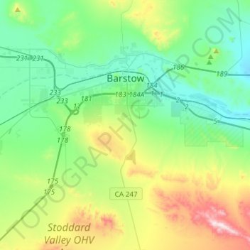
Name: Barstow topographic map, elevation, terrain.
Location: Barstow, San Bernardino County, California, United States (34.80536 -117.15369 34.91820 -116.90910)
Average elevation: 770 m
Minimum elevation: 597 m
Maximum elevation: 1,236 m
Other topographic maps
Click on a map to view its topography, its elevation and its terrain.
Fort Irwin
United States > California > San Bernardino County
Fort Irwin National Training Center (Fort Irwin NTC) is a major training area for the United States military in the Mojave Desert in northern San Bernardino County, California. Fort Irwin is at an average elevation of 2,454 feet (748 m). It is located 37 miles (60 km) northeast of Barstow, in the Calico…
Average elevation: 774 m
Devil Canyon
United States > California > San Bernardino County > San Bernardino
Average elevation: 628 m
Running Springs
United States > California > San Bernardino County
Running Springs is a mountain community in the San Bernardino Mountains. It is an inholding in the San Bernardino National Forest. Situated at the junction of State Route 18 and State Route 330, it is a major gateway to the mountain communities of Lake Arrowhead, Arrowbear, Green Valley Lake, and Big Bear and…
Average elevation: 1,656 m
East Colton Heights
United States > California > San Bernardino County > Colton
Average elevation: 326 m
Los Serranos
United States > California > San Bernardino County > Chino Hills
Average elevation: 212 m
Meadowbrook Woods
United States > California > San Bernardino County > Lake Arrowhead
Average elevation: 1,560 m
targets?
United States > California > San Bernardino County > Lucerne Valley
Average elevation: 1,291 m
Moonridge
United States > California > San Bernardino County > Big Bear Lake
Average elevation: 2,211 m
Devils Canyon Dike Number 1 17-002 Dam
United States > California > San Bernardino County > San Bernardino
Average elevation: 519 m
Cajon Pass
United States > California > San Bernardino County
Cajon Pass (/kəˈhoʊn/; Spanish: Puerto del Cajón or Paso del Cajón) is a mountain pass between the San Bernardino Mountains to the east and the San Gabriel Mountains to the west in Southern California. Created by the movements of the San Andreas Fault, it has an elevation of 3,777 ft (1,151 m). Located in…
Average elevation: 1,169 m
Moonridge
United States > California > San Bernardino County > Big Bear Lake
Average elevation: 2,211 m
Cotners Corner
United States > California > San Bernardino County > Apple Valley
Average elevation: 915 m
Running Springs
United States > California > San Bernardino County
Running Springs is a mountain community in the San Bernardino Mountains. It is an inholding in the San Bernardino National Forest. Situated at the junction of State Route 18 and State Route 330, it is a major gateway to the mountain communities of Lake Arrowhead, Arrowbear, Green Valley Lake, and Big Bear and…
Average elevation: 1,656 m
Crest Line Park
United States > California > San Bernardino County > Crestline
Average elevation: 1,452 m
City Creek
United States > California > San Bernardino County > San Bernardino
Average elevation: 363 m
Arrowbear Lake
United States > California > San Bernardino County > Running Springs
Arrowbear Lake is an unincorporated community in San Bernardino County, California, United States. Its altitude is 6,086 feet (1,855 m), in the San Bernardino Mountains.[1]
Average elevation: 1,928 m
Yucca Valley
United States > California > San Bernardino County
Yucca Valley lies in the middle of the Morongo Basin at a base elevation of 3,300 feet. Joshua Tree National Park is adjacent to its southern border.
Average elevation: 1,106 m
Twentynine Palms
United States > California > San Bernardino County > Twentynine Palms
According to the United States Census Bureau, the city has a total area of 59.1 square miles (153 km2), all land. The city is at an elevation of 1,988 feet (606 m). The Marine Corps Air Ground Combat Center Twentynine Palms is located there.
Average elevation: 690 m
Big Bear Lake
United States > California > San Bernardino County > Big Bear Lake > Big Bear Lake
Since 1970, Big Bear Lake has held its annual Oktoberfest. The Big Bear Lake Oktoberfest also sports the highest beer garden, by elevation, in the United States. Big Bear Lake was incorporated as a city on November 28, 1980.
Average elevation: 2,184 m
Arrowbear Lake
United States > California > San Bernardino County > Running Springs
Arrowbear Lake is an unincorporated community in San Bernardino County, California, United States. Its altitude is 6,086 feet (1,855 m) in the San Bernardino Mountains. It is located east of Running Springs along Highway 18 in the San Bernardino National Forest, a mountain community with a population of 736 in…
Average elevation: 1,928 m
Sierra Heights
United States > California > San Bernardino County > Fontana > Sierra Heights
Average elevation: 570 m
Green Valley Lake
United States > California > San Bernardino County > Green Valley Lake
Average elevation: 2,036 m
Big Bear City
United States > California > San Bernardino County > Big Bear City
It is estimated that the Serrano natives first settled in Big Bear between 1,500 and 2,000 years ago. The Serranos had both winter and summer settlements throughout the area. While their winter village was located in Lucerne Valley, they relocated to villages in the San Bernardino mountains during summer, as…
Average elevation: 2,155 m